Carson Pass Day Hikes
From Easy Walks to Day-long Adventures
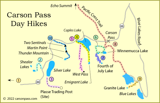
Hiking on Carson Pass can be as strenuous or as easy as you choose. One of the best hikes is the climb to the summit of Thunder Mountain overlooking Silver Lake. Around Silver Lake and out by Blue Lakes are a number of dirt roads and trails that are fun to explore.
At Caples Lake are trails that take you out to the Carson River Emigrant Trail, a route used by emigrants with wagons heading west during the Gold Rush years. At the very top of Carson Pass you can follow the famous Pacific Crest Trail either north or south.
1. Indian Grinding Rock State Park Hikes
South Nature Trail
Distance: 0.5-mile loop, level trail
Elevation Changes: minor
South Nature Trail is a self-guided interpretive path keyed to a park pamphlet.
As you tour meadowland, oak woods, plus stands of sugar pine and ponderosa pine, you'll
learn how the Miwok collected and used the bountiful local vegetation.
North Trail
Distance: 1 mile loop, easy trail
Elevation Changes: minor
North Trail begins near the museum.
It follows a low ridge and loops back to the reconstructed Miwok village.
At the village, you can join South Nature Trail or return to the museum via a
more direct route past the ceremonial roundhouse.
2. Silver Lake to Shealor Lakes
Distance: 1.8 miles one way to upper lake, 1 mile more to lower lake, mountain trail
Elevation Changes: 200 feet up, 400 feet down - 7,450' to 7,600' to 7,200'
Find the trailhead to Shealor Lakes on Highway 88, 1.2 miles west of Silver Lake. This hike climbs,
drops, climbs, and then drops again to the lower lake. Along the way you have wonderful views back to the east
overlooking Silver Lake with Thunder Mountain and thimble Peak for the backdrop. There is no trail down to the
lower lake, so it is a route for experienced cross-country hikers. The trail descends another 500 feet to the
lower lake, leaving you with a 900-foot return climb.
3. Silver Lake to Plasse's Trading Post Site
Distance: 3.75 miles one way, 4-wheel road
Elevation Changes: 1,300 feet up - 7,300' to 8,600'
Anyone interested in emigrant trail history would enjoy the nearly 4-mile hike to the site of
Plasse's Trading Post on the Carson Emigrant Trail. Begin at Plasse's Resort at the southern end of
Silver Lake. The 4-wheel road passes Stockton Municipal Camp, climbing evenly over the entire 4 miles. Side
trips along the way could take you to Hidden Lake or to several early grave sites near the trading post site.
4. Caples Lake to Emigrant Lake
Distance: 4 miles one way, mountain trail
Elevation Changes: 800 feet gain - 7,800' to 8,600'
Set out from the trailhead next to Highway 88 at the western tip of Caples Lake. Enjoy a scenic day trek to Emigrant Lake, hiking part of the way along the shore of Caples Lake.
You'll have plenty of views of Caples Lake on the first half of the hike along level terrain, and then you get a good look up at the West Pass, the highest summit the
wagons had to cross while traveling the Carson Emigrant Trail. Camping is not allowed within 300 feet of Emigrant Lake. Enjoy a snack or lunch at picturesque Emigrant Lake and then relax on the return hike.
5. Caples Lake to West Pass
Distance: 5 miles one way, mountain trail
Elevation Changes: 1800 feet gain - 7,800' to 9,600'
Set out from the trailhead next to Highway 88 at the western tip of Caples Lake. Start out along the lake's edge, but after a little more than a mile turn uphill on the trail to West Pass. This is the route of the Carson River Emigrant Trail. The emigrants came down from Carson Pass and crossed the valley where Caples Lake now is before starting the arduous climb to West Pass.
Along the way you will cross under ski lifts from Kirkwood Ski Area. Then after mile 3 the serious climbing begins, up the side of Covered Wagon Peak. Be sure to carry water and a camera. Panoramic views from the top are spectacular.
TOP
6. Woods Lake to Round Top Lake and Winnemucca Lake Loop
Distance: 4.2 mile loop, mountain trail
Elevation Changes: 1,200 feet up - 8,200' to 9,400'
The hike up to Round Top Lake is a favorite for anyone camped at Woods Lake. The trail passes the Lost Cabin Mine on the way up. Experienced mountain climbers may push on to summit Round Top (10,381'). Once you have reached Round Top Lake it only makes sense to climb a slight rise and return to Woods Lake via Winnemucca Lake.
7. Woods Lake to Fourth of July Lake
Distance: 3.6 miles one way, mountain trail
Elevation Changes: 1,200 feet up - 8,200' to 9,400' and then down 1,200' to 8,200'
Fourth of July Lake is an ambitious hike for a single day trip. The trail leaves Woods Lake and climbs
1,200' to Round Top Lake and then drops 1,200' to Fourth of July Lake. The return hike on weary legs can be
a challenge. Most people prefer this hike as an overnight backpack trip. There are amazing views from Fourth of
July Lake. It rests in a pocket overlooking Summit City Creek canyon, nearly 900 feet below.
8. Pacific Crest Trail
South on the PCT
Distance: pick your distance, mountain trail
Elevation Changes: 1,200 feet up - 8,600' to 9,100' to 8,200'
The Pacific Crest Trail crosses Carson Pass just west of the parking lot. Day hikes on the trail
are enjoyable because it offers wonderful views. To the south there is no clear destination until you reach
Lost Lakes nearly 7 miles out. Most day hikes go out about 2.5 miles to the south and turn around before the
trail begins its serious descent.
North on the PCT
Distance: pick your distance, mountain trail
Elevation Changes: 400 - 500 feet up - 8,600' to 9,000'
Going north, the Pacific Crest Trail only fluctuates a couple hundred feet in elevation for the first 4.5 miles,
all the way to Showers Lake. For a more ambitious hike, if you arranged a shuttle, someone could drive over Luther Pass and up to the top
of Echo Summit and leave a car there or be there to wait for hikers. The hike from Carson Pass to Echo Summit is
12 miles over fairly even terrain. The trail never climbs more than 500 feet over the first 9 miles. After that
it descends 700 feet to Echo Summit.
Wendy Lautner's Day & Section Hikes, Pacific Crest Trail Northern California, shown right, includes many of the day hikes listed on this page, besides covering the Pacific Crest Trail.
9. Blue Lakes to Granite Lake
Distance: 1.75 miles one way, mountain trail
Elevation Changes: 550 feet up - 8,100' to 8,750'
Little Granite Lake makes an interesting half day hike from Blue Lakes. Start out at the Middle Creek
Campground and head west up the trail, passing a tiny unnamed lake along the way. From Granite Lake you
have nice views back down on Upper Blue Lake. Fishing is good in Granite Lake for Lahontan cutthroat trout.
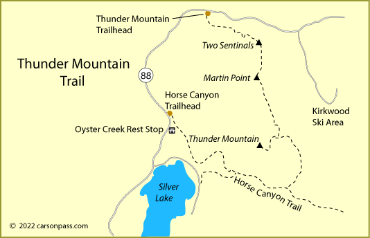
10. Thunder Mountain
Distance: 3.5 miles one way, mountain trail
Elevation Changes: 1,500 feet up - 7,900' to 9,400'
The Thunder Mountain trail doesn't appear on older maps, but it is one of the best day hikes
in the Carson Pass area. Begin at the Thunder Mountain trailhead between Silver Lake and Kirkwood. The
trail climbs steadily up to Two Sentinels and then along the ridge to Martin Point
and culminates on the 9,408-foot summit of Thunder Mountain. Views from the summit are unmatched.
For anyone wanting to make a loop trip, a trail continues south and then west to connect with the Horse Canyon trail. Following that trail carries hikers back past the Kit Carson Lodge area at Silver Lake and on to the trailhead on Highway 88, near Oyster Creek Rest Stop (4.5 miles).