HOME
Lodging and Camping
Recreation Areas
- Bear River Reservoir
- Blue Lakes
- Caples Lake
- Carson Pass
- Hope Valley
- Indian Grinding Rock SP
- Kirkwood
- Silver Lake
- Volcano
Outdoor Recreation
- Backpacking
- Bicycling
- Boating
- Day Hiking
- Fishing
- Golf
- Historic Sites
- Horseback Riding
- Mountain Biking
- OHV
- Picnicking
Winter Recreation
Events and Services
The World Rushed In
The best book on the Gold Rush ever published
The Early History of Carson Pass
The Carson River Trail was discovered by Mormon volunteers serving in the West during the war with Mexico. Following the war in 1847 about 100 of the Mormon soldiers found employment with John Sutter in Sacramento during the winter to build up supplies for the return trip to Mormon settlements in the Great Salt Lake Valley. Forty-five men and one woman set out in 1848 with wagons, mules, and horses, working their way up the ridge between the American and Mokelumne rivers.
Their course followed what today is called Hungalelti Ridge (formerly Squaw Ridge), over West Pass, through the valley where Caples Lake now lies, and on over Carson Pass. From there they swung northeast, joining the already established California Trail leading over Donner Summit. Thus, the Mormon company forged 170 miles of new trail that would become the most popular emigrant route into California. Today you will find a commemorative marker at the Shot Rock Vista 6 miles west of Silver Lake.
Several years earlier in 1844, John Charles Fremont led his exploring party from the Markleeville area up over the Sierra summit at a point slightly south of Carson Pass. On that trip Fremont named the Carson River in honor of one of his guides, Kit Carson. The later emigrant trail was named after the river it followed, as were other trails to California.
Along the Mormon - Carson River Emigrant Trail
Tragedy Springs
On June 27, 1848 three members of the Mormon Battalion scouting ahead for a route over the mountains were murdered by unknown persons at Tragedy Springs. Members of the Battalion arrived to find their bodies. They were buried there and their names - Henderson Cox, Ezra Allen, and Daniel Browett - were carved on a nearby tree. In later years the springs was a popular stopping place for emigrants traveling west.
Today there are commemorative markers at the site on Tragedy Springs Road, which leads off Highway 88 two and a half miles west of Silver Lake.
Maiden's Grave
Maiden's Grave was thought to be the resting place of Rechall Melton who was presumed buried there on October 4, 1850. She died near that spot while traveling west along the emigrant trail. Later events suggested that Rechall (or Rachel, last name unknown) may actually have been buried in a meadow two miles away. The marked grave is probably that of Allen Melton, another emigrant.
A commemorative marker is found there, about half way between the Shot Rock Overlook and Tragedy Springs.
Plasse's Trading Post
The early Plasse Trading Post was established by Raymond Peter Plasse in 1853 along the emigrant trail, south of today's Plasse's Resort.
A commemorative marker is found there, about half way between the Shot Rock Overlook and Tragedy Springs.
Odd Fellows Inscriptions
On some large rocks near Carson Pass, a group of pioneers inscribed their names and the emblem of the Independent Order of Odd Fellows in 1849. A memorial is found along Highway 88 about 14½ miles west of Woodfords.
For a detailed guide to hiking the emigrant trail, pick up a copy of Frank Tortorich, Jr.'s Hiking the Gold Rush Trail, a
Hiking Guide over West Pass, Caples Lake to Tragedy Spring, 2004. The book is available from
The Oregon-California Trails Association.
TOP
Lumberyard Ranger Station
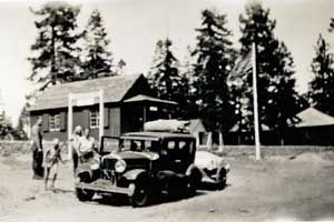
Lumberyard Ranger Station, 1934
The old Lumberyard Ranger Station, 4 miles east of Hams Station, long served as the main ranger outpost on Carson Pass.
At one time there was a campground next to the ranger station, but that campground has been closed.
TOP
Kirkwood
The Kirkwood Inn was the pioneer home of Zachary Kirkwood, who built the hostelry in 1864. Zachary and his wife Elizabeth farmed and raised stock in the area of today's Kirkwood Meadow. When Alpine County was formed from Amador County, the split put the Kirkwoods' barn and milk house in Alpine, but the barroom of the inn was divided down the middle between the two counties.
TOP
Woodfords - Pony Express Station
The town of Woodfords on the east side of Carson Pass was picked as a remount station of the Pony Express on April 4, 1860. Cary's Barn was selected for the station. Five weeks later the pony express was rerouted by way of Echo Summit and Luther Pass.
Woodfords holds title as the oldest non-native settlement in the entire region. To commemorate the Pony Express Ride, every summer a group of volunteer equestrians re-enact the historic route, passing through Woodfords during the National Pony Express Re-Ride. A marker commemorating the Woodfords Pony Express station is located at the intersection of highways 88 and 89.
TOP
Volcano - Gold Rush Town
Volcano began as a Gold Rush town with miners working in places like Soldiers Gulch and Clapboard Gulch, hauling their paydirt by hand to the nearest water supply to wash out the gold. One miner reportedly found $8000 worth of gold in a single day. Another mined 28 pounds from a single pocket. By 1851 to town had grown to 300 houses and two years later there were 11 stores, 6 hotels, 3 bakeries, and 3 saloons. Beginning in 1855, hydraulic mining changed the landscape around Volcano, washing away tons of dirt and leaving odd formations of rock exposed above the ground.
Now Volcano has only about 100 residents. There are quaint shops to visit, historic buildings, a theater company, and restaurants, hotels, and pubs. The St. George Hotel is on National Register of Historic Places. Nearby is the famous Daffodil Hill, a private 4-acre farm that bursts into bloom every spring and draws thousands of visitors.
On the knoll behind a marker near Volcano, George Madeira built the first amateur astronomical observatory of record in California. It was there that he discovered the Great Comet of 1861 with a three-inch refractor telescope.